Contact Us for your Ads Here
Showing posts with label Weather Report. Show all posts

Friday, December 17, 2021

Cebu is in Chaos after Odette Struck overnight.

Blog Post Standard Photo

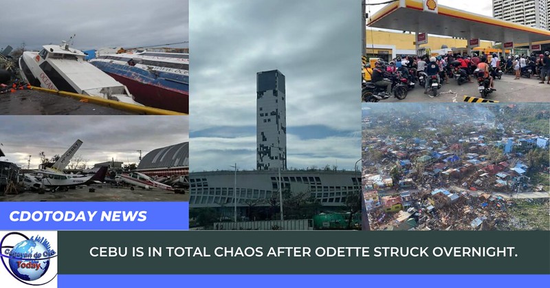
Cebu was hit hard by Super Typhoon Odette, First time in Cebu to experience being hit by a typhoon as strong as Typhoon Odette. Some said they never thought the destruction was like this. That is why most people in Cebu didn't prepared much about the outcome of the typhoon.

266266409_261425709312010_2071163843903978843_n
268802572_3171588926394007_6727915359125909018_n


No Flights in Mactan Airport starting today until further notice. Ships in piers are damaged. No services on ships as of this posting. No Electricity, No water, no Mobile Data Signal, No internet connection, No Gasoline available.


Gas station

In short, Cebu is in Chaos and Disconnected and shutdown.


Most high rise buildings are damaged, no services mostly in all businesses like banks, hotels, convenient stores, supermarkets, gas stations, etc.


SM Seaside

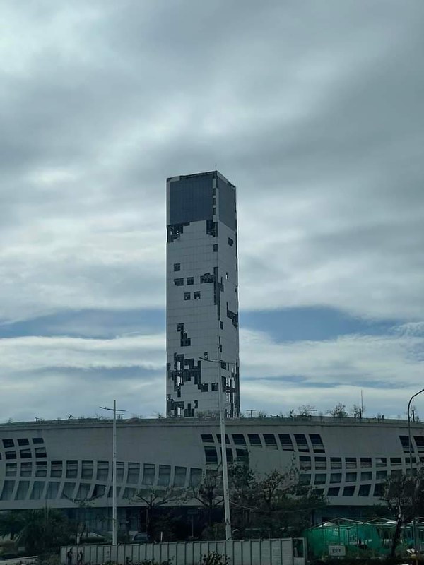
Please help Cebu and include them in your prayers.


Wednesday, December 15, 2021

STREET FLOODING UPDATE: 8:45 AM 16 DECEMBER 2021

STREET FLOODING UPDATE


Motorists of all types will NOT be allowed to pass across the road of Kauswagan Highway (Honda Side). Vehicles from Bulua heading into the city will use the other lane (SnR side).


Villarin Street in Carmen is not passable to all types of vehicles.


STREET FLOODING UPDATE1336_270507198438671_4221701618860306723_n

STREET FLOODING UPDATE

Everyone is urged to remain alert and vigilant due to the rain we are experiencing in the city due to Typhoon “ODETTE”.

General Flood Advisory for CAGAYAN DE ORO RIVER BASIN & ALLIED RIVERS from PAGASA

267515845_270448918444499_2210630038839468827_n

The center of Typhoon “ODETTE” is already located 355 km in the Eastern part of Surigao City, Surigao del Norte; speed 155 kph and moving 25 kph West Northwestward around 3:00 p.m.


Due to the current weather conditions, Northern Mindanao will experience moderate to heavy rainfall due to Typhoon “ODETTE”.


Based on the 12 -hour rainfall forecast, experience moderate to heavy rainfall where the water it carries is likely to pass through:


Misamis Oriental - Rivers and tributaries of Odiongan, Gingoog, Balatocan, Cabulig, Lower Tagoloan, Lower/Middle Western Cagayan, Iponan and Alubijid.

Bukidnon - Rivers and tributaries of Upper Tagaloan and Upper/Eastern Cagayan.

Lanao del Norte - Rivers and tributaries of Mandulog, Agus, Liangan and Maranding.

Misamis Occidental - Rivers and tributaries of Clarin, Palilan and Aloran.

Camiguin - All Rivers and Tributaries.

Cagayan and Iponan rivers are at NORMAL Level as of 8:00AM (Dec 16, 2021)

Water level of CDO River


Moderate to heavy rain was experienced in other parts of the CDO at this time.


Moderate to occasionally heavy rainfall was experienced in other parts of Libona; Mampayag, Dahilayan and Lindaban, Manolo Fortich this hour.


Moderate to occasionally heavy rain was also experienced in other parts of Talakag and Baungon at this time.


The water LEVEL in the Cagayan and Iponan rivers are NORMAL.

Heavy Rainfall Warning in CDO, MisOr and Camiguin

Heavy Rainfall Warning


Heavy Rainfall Warning No.6-A #MIN_PRSD

Issued at 6:30 AM, Thursday 16 December 2021

Weather System: Typhoon #OdettePH

ORANGE Rainfall Warning Level: #CagayandeOroCity, #MisamisOriental , #Camiguin

Red Rainfall Warning in Agusan del Norte, Agusan del Sur, and Bukidnon.


Community Preparedness

*FLOODING in low lying areas and near river channels and LANDSLIDES in landslide prone areas are threatening.

Meanwhile, moderate with at times heavy #rains are being experienced over #ZamboangadelSur and may affect nearby areas.

The public and the disaster risk reduction and management council concerned are advised to take appropriate actions, MONITOR the weather condition and watch for the next advisory to be issued at 8:00 AM today.

For more information and queries, please call telephone number (088) 555-0485

Tuesday, December 14, 2021

TYPHOON PREPAREDNESS TIPS ADAPTED FOR THE PHILIPPINES

TYPHOON PREPAREDNESS TIPS ADAPTED FOR THE PHILIPPINES


Before a typhoon hits

To prepare for a Typhoon, you should take the following measures:
  • To begin preparing, you should build an emergency kit and make a family communications plan.
  • Know your surroundings.
  • Learn the elevation level of your property and whether the land is flood-prone. This will help you know how your property will be affected when storm surge or tidal flooding are forecast.
  • Identify levees and dams in your area and determine whether they pose a hazard to you.
  • Learn community Typhoon evacuation routes and how to find higher ground. Determine where you would go and how you would get there if you needed to evacuate.
  • Make plans to secure your property:
  • Cover all of your home’s windows. Permanent storm shutters offer the best protection for windows. A second option is to board up windows with 5/8” marine plywood, cut to fit and ready to install. Tape does not prevent windows from breaking.
  • Install straps or additional clips to securely fasten your roof to the frame structure. This will reduce roof damage.
  • Be sure trees and shrubs around your home are well trimmed so they are more wind resistant.
  • Clear loose and clogged rain gutters and downspouts.
  • Reinforce your garage doors; if wind enters a garage it can cause dangerous and expensive structural damage.
  • Plan to bring in all outdoor furniture, decorations, garbage cans and anything else that is not tied down. 
  • In a strong typhoon, A LOOSE OBJECT IS A MISSILE!
  • Determine how and where to secure your boat.
  • If in a high-rise building, be prepared to take shelter on or below the 10th floor.

During a Typhoon

If a Typhoon is likely in your area, you should:

  • Listen to the radio or TV for information.
  • Secure your home, close storm shutters and secure outdoor objects or bring them indoors.
  • Turn off utilities (electricity) if instructed to do so. Otherwise, turn the refrigerator thermostat to its coldest setting and keep its doors closed.
  • Turn off LPG tanks
  • Avoid using the phone, except for serious emergencies.
  • Moor your boat if time permits.
  • Ensure a supply of water for sanitary purpose such as cleaning and flushing toilets. Fill the bathtub and other larger containers with water.
  • Find out how to keep food safe during and after and emergency.
You should evacuate under the following conditions:
  • If you are directed by local authorities to do so. Be sure to follow their instructions.
  • If you live in a weak home or temporary structure – such shelter are particularly hazardous during Typhoon no matter how well fastened to the ground.
  • If you live in a high-rise building – Typhoon winds are stronger at higher elevations.
  • If you live on the coast, on a floodplain, near a river, or on an island waterway.

Read more about evacuating yourself and your family. If you are unable to evacuate, go to your wind-safe room. If you do not have one, follow these guidelines:
  • Stay indoors during the Typhoon and away from windows and glass doors.
  • Close all interior doors – secure and brace external doors.
  • Keep curtains and blinds closed. Do not be fooled if there is a lull; it could be the eye of the storm – winds will pick up again.
  • Take refuge in a small interior room, closet or hallway on the lowest level.
  • Lie on the floor under a table or another sturdy object.
  • Avoid elevators.


"ODETTE” SLIGHTLY INTENSIFIES AND IS NEARING TYPHOON CATEGORY IN STRENGTH

TROPICAL CYCLONE BULLETIN NO. 2

Severe Tropical Storm “#OdettePH
Issued at 5:00 AM, 15 December 2021
Valid for broadcast until the next bulletin at 11:00 AM today

TROPICAL CYCLONE WIND SIGNALS (TCWS) IN EFFECT
 
“ODETTE” SLIGHTLY INTENSIFIES AND IS NEARING TYPHOON CATEGORY IN STRENGTH

Location of Center (4:00 AM): The center of Severe Tropical Storm “ODETTE” was estimated based on all available data at 735 km East of Hinatuan, Surigao del Sur (8.8°N, 133.0°E)
Intensity: Maximum sustained winds of 110 km/h near the center, gustiness of up to 135 km/h, and central pressure of 980 hPa
Present Movement: West Northwestward at 25 km/h
Extent of Tropical Cyclone Winds: Strong winds or higher extend outwards up to 330 km from the center

TROPICAL CYCLONE WIND SIGNALS (TCWS) IN EFFECT: TCWS No. 1 (Strong winds prevailing or expected within 36 hours)

Visayas
Northern Samar, Eastern Samar, Samar, Biliran, Leyte, Southern Leyte, Bohol, and the northern and central portions of Cebu (Daanbantayan, Medellin, City of Bogo, San Remigio, Tabogon, Borbon, Sogod, Catmon, Carmen, Danao City, Compostela, Liloan, Tabuelan, Tuburan, Asturias, City of Carcar, Pinamungahan, San Fernando, Toledo City, City of Naga, Balamban, Minglanilla, Cebu City, City of Talisay, Consolacion, Mandaue City, Lapu-Lapu City, Cordova) including Bantayan and Camotes Islands.

Mindanao
Dinagat Islands, Surigao del Norte, Surigao del Sur, Agusan del Norte, Agusan del Sur, Camiguin, and the eastern portion of Misamis Oriental (Magsaysay, Gingoog City, Medina, Talisayan, Balingoan, Kinoguitan, Sugbongcogon, Salay, Jasaan, Balingasag, Lagonglong, Binuangan, Claveria, Villanueva, Tagoloan)

HAZARDS AFFECTING LAND AREAS

Heavy Rainfall
• Today through tomorrow early morning: Light to moderate with at times heavy rains are possible over Surigao del Norte, Surigao del Sur, and Dinagat Islands due to the trough and the outermost rain bands of “ODETTE”

• Tomorrow early morning through Friday early morning: Heavy to intense with at times torrential rains over Dinagat Islands, Surigao del Norte, the northern portion of Surigao del Sur, Agusan del Norte, the northern portion of Agusan del Sur, Camiguin, Misamis Oriental, Southern Leyte, Bohol, Negros Oriental, and Cebu. Moderate to heavy with at times intense rains over Leyte, the southern portion of Eastern Samar, Siquijor, and the rest of Caraga. Light to moderate with at times heavy rains over Bicol Region, Zamboanga del Norte, Oriental Mindoro, Romblon, and the rest of Visayas and Northern Mindanao

• Friday early morning through Saturday early morning: Heavy to intense with at times torrential rains over Western Visayas, and the northern and central portions of Palawan including Cuyo and Cagayancillo Islands. Moderate to heavy with at times intense rains over Occidental Mindoro, Oriental Mindoro, and Negros Oriental. Light to moderate with at times heavy rains over Bicol Region, Northern Mindanao, Caraga, Zamboanga del Norte, Quezon, Aurora, the eastern portions of Cagayan and Isabela, and the rest of Visayas.

• Under these conditions, scattered to widespread flooding (including flash floods) and rain-induced landslides are expected especially in areas that are highly or very highly susceptible to these hazard as identified in hazard maps, and in localities with significant antecedent rainfall.

Severe Winds

• Strong winds (strong breeze to near gale) with higher gusts will be experienced within any of the areas where TCWS #1 is currently in effect during the passage of the severe tropical storm. This may generally bring up to very light damage to structures and vegetation.

• Areas under TCWS will be expanded in succeeding bulletins, while the hoisted wind signals in some localities of the country will be upgraded as “ODETTE” moves closer. TCWS #2 may be hoisted this morning or afternoon for some areas currently under TCWS #1. The highest level of wind signal that may be hoisted during the passage of “ODETTE” is TCWS #3 due to possible destructive typhoon-force winds in localities near or along the path of this tropical cyclone.

HAZARDS AFFECTING COASTAL WATERS

• In the next 24 hours, moderate to high seas (1.2 to 7.0 m) will be experienced over the seaboards of areas where TCWS #1 is in effect (especially in the open sea areas). These conditions are risky for all types of sea vessels. Mariners are advised to remain in port or take shelter in port until winds and waves subside.

• Under the influence of Severe Tropical Storm “ODETTE” and the prevailing Northeast Monsoon, a Gale Warning remains in effect for the seaboards of Northern Luzon, the eastern seaboard of Central Luzon, the eastern and western seaboards of Southern Luzon, the western seaboard of Visayas, and the eastern seaboard of Mindanao not under any wind signal. For more information, refer to Gale Warning #47 issued at 5:00 AM today.

• In the next 24 hours, moderate to rough seas (1.2 to 3.1 m) will also prevail over the remaining seaboards of Central Luzon, Southern Luzon, and Visayas, and the western and northern seaboards of Mindanao that are not under any wind signal. These conditions are risky for those using small seacrafts. Mariners are advised to take precautionary measures when venturing out to sea and, if possible, avoid navigating in these conditions.


TRACK AND INTENSITY OUTLOOK

• “ODETTE” is forecast to move west northwestward until this afternoon, then westward thereafter. On the forecast track, the center of this tropical cyclone is forecast to make landfall in the vicinity of Caraga or Eastern Visayas tomorrow afternoon or evening. Afterwards, the center of “ODETTE” will continue moving generally westward and cross several provinces in Central and Western Visayas regions before emerging over the Sulu Sea on Friday morning or afternoon. After passing near or over the Cuyo archipelago, this tropical cyclone is forecast to cross the northern portion of Palawan on Friday evening before emerging over the West Philippine Sea.

• Further intensification is expected today through tomorrow as the severe tropical storm crosses the Philippine Sea. “ODETTE” is forecast to intensify into a typhoon within 12 hours and may reach a peak intensity of 155 km/h prior to making landfall tomorrow afternoon or evening. This tropical cyclone may see some slight weakening as it crosses the Visayas and Palawan, but it is forecast to remain within the typhoon category. Re-intensification is likely once “ODETTE” emerges over the West Philippine Sea.


Considering these developments, the public and disaster risk reduction and management offices concerned are advised to take all necessary measures to protect life and property. Persons living in areas identified to be highly or very highly susceptible to these hazards are advised to follow evacuation and other instructions from local officials. For heavy rainfall warnings, thunderstorm/rainfall advisories, and other severe weather information specific to your area, please monitor products issued by your local PAGASA Regional Services Division.
The next tropical cyclone bulletin will be issued at 11:00 AM today.

Monday, December 13, 2021

Mandangoa Spillway in Balingasag Overflows as TS Odette is Approaching

Mandangoa Spillway in Balingasag, Misamis Oriental

Situation of the Mandangoa Spillway in Balingasag, Misamis Oriental. Authorities has been monitoring closely the situation while Tropical Storm Odette is approaching.


“RAI” or TROPICAL STORM ODETTE INTENSIFIES INTO SEVERE TROPICAL STORM WHILE MOVING WEST NORTHWESTWARD TOWARDS PALAU.

TROPICAL CYCLONE ADVISORY NO.6

Severe Tropical Storm "RAI"
Issued at 11:00AM, 14 December 2021
Valid for broadcast until the next advisory at 11:00PM today
“RAI” INTENSIFIES INTO SEVERE TROPICAL STORM WHILE MOVING WEST NORTHWESTWARD TOWARDS PALAU.
Odette Sat Image


Location of Center (10:00 AM): The center of the Severe Tropical Storm “RAI” was estimated based on all available data at 1,165 km East of Mindanao (7.3°N, 136.4°E) (outside the PAR)
Intensity: Maximum sustained winds of 95 km/h near the center, gustiness up to 115 km/h, and central pressure of 990 hPa
Present Movement: West northwestward at 30 km/h

GENERAL OUTLOOK FOR THE FORECAST PERIOD

• Severe Tropical Storm “RAI” is forecast to move west northwestward while gradually intensifying and enter the Philippine Area of Responsibility (PAR) as a severe tropical storm this afternoon or evening. Once inside PAR, the domestic name “ODETTE” will be assigned to this tropical cyclone. “RAI” will begin moving westward over the Philippine Sea on Wednesday afternoon and may make landfall in the vicinity of Caraga or Eastern Visayas by Thursday (16 December) afternoon or evening. While inside the PAR, favorable atmospheric conditions will favor sustained intensification prior to landfall. This tropical cyclone is forecast to reach typhoon category on Wednesday. A pre-landfall peak intensity of around 155 km/h may be reached by Thursday morning or afternoon.

• There is a high likelihood that Tropical Cyclone Wind Signals will be hoisted for Visayas, large portions of Mindanao, and several provinces in Southern Luzon due to the threat of strong to typhoon-force winds associated with the passage of “RAI”. The highest possible wind signal that may be hoisted is TCWS #3. Localities situated in the eastern portions of Visayas and Mindanao may be placed under TCWS #1 as early as this afternoon or evening.

• In the next 24 hours, the trough of Severe Tropical Storm “RAI” will bring light to moderate with at times heavy rains over Caraga and Davao Oriental. The passage of this tropical cyclone over the central portion of the archipelago may bring heavy to torrential rainfall over Visayas, Mindanao, and several provinces in Southern Luzon, which may bring possible flooding and rain-induced landslides. Coastal inundation due to high waves near the coast and storm surge are also possible for low-lying localities near and along the path of the typhoon. Residents over the northern and eastern portions of Northern Luzon and the eastern portion of Central Luzon are also advised to monitor for updates regarding possible heavy rainfall which may occur in relation to the behavior of the shear line during and after the passage of this tropical cyclone.

• The passage of “RAI” will bring rough to high seas (reaching very high or phenomenal in open sea near the center of the cyclone) over the seaboards of Southern Luzon and Visayas, and the northern, eastern, and western seaboards of Mindanao. Rough to high seas are also possible for the seaboards of Northern and Central Luzon. Sea travel is risky for all types of seacrafts over these waters.

• Moderate to rough seas are also possible for the remaining seaboards of Mindanao during the passage. Sea travel is risky over these waters for small seacrafts.

Considering these developments, the public and disaster risk reduction and management offices concerned are advised to continue monitoring for updates related to this tropical cyclone.
Unless an intermediate advisory or initial tropical cyclone bulletin is released, the next tropical cyclone advisory will be issued at 11:00 PM today.

Typhoon #OdettePH has not yet entered the PAR but Gingoog City is experiencing floods

Gingoog Flood

The local government of Gingoog City is currently conducting rescue operations through the 24/7 Emergency Response Command Center with CDRRMO on the affected residents of Barangays 1, 9, 24 and 25 of of Gingoog City.


It will be noted that these barangays are located next to the flood control dikes with on-going construction. Due to the torrential rains the water level in such dikes rises.


Currently, the affected residents are able to evacuate the Barangay Halls and Evacuation Centers while also conducting and distributing relief goods to the affected families.

Tropical Storm Odette is Coming!

Typhoon

THE TROPICAL DEPRESSION OUTSIDE THE PHILIPPINE AREA OF RESPONSIBILITY (PAR) INTENSIFIES INTO TROPICAL STORM “RAI”.

Location of Center (4:00 PM): The center of the Tropical Storm “RAI” was estimated based on all available data at 1,630 km East of Mindanao (5.7°N, 140.5°E) (outside the PAR) 


Intensity: Maximum sustained winds of 65 km/h near the center, gustiness up to 80 km/h, and central pressure of 998 hPa 


Present Movement: West northwestward at 20 km/h 


GENERAL OUTLOOK FOR THE FORECAST PERIOD

Storm Track

• The tropical storm is forecast to move west northwestward and will likely enter the PAR region as a severe tropical storm tomorrow (14 December) evening. Once inside PAR, the domestic name “ODETTE” will be assigned to this tropical cyclone. The west northwestward movement is forecast to continue until Wednesday (15 December) morning or afternoon. Afterwards, the tropical cyclone will turn westward and may make landfall in the vicinity of Caraga or Eastern Visayas by Thursday (16 December) afternoon or evening.


• “RAI” intensified into tropical storm at 2:00 PM today. This tropical cyclone is forecast to gradually intensify within the forecast period and may reach typhoon category by Wednesday. A peak intensity of around 155 km/h may be reached prior to landfall.


• Current track and intensity forecast shows that there is a high likelihood that Tropical Cyclone Wind Signals will be hoisted for Visayas, large portions of Mindanao, and several provinces in Southern Luzon due to the threat of strong to typhoon-force winds. The highest possible wind signal that may be hoisted is TCWS #3. Localities situated in the eastern portions of Visayas and Mindanao may be placed under TCWS #1 as early as tomorrow afternoon or evening.


• The passage of this tropical cyclone over the central portion of the archipelago may bring heavy rainfall over Visayas, large portions of Mindanao, and several provinces in Southern Luzon. Coastal inundation due to high waves near the coast and storm surge are also possible for low-lying localities near and along the path of the typhoon. Residents over the northern and eastern portions of Northern Luzon and the eastern portion of Central Luzon are also advised to monitor for updates regarding possible heavy rainfall which may occur in relation to the behavior of the shear line during and after the passage of this tropical cyclone.


Forecast

Considering these developments, the public and disaster risk reduction and management offices concerned are advised to continue monitoring for updates related to this tropical cyclone.


Unless an intermediate advisory or initial tropical cyclone bulletin is released, the next tropical cyclone advisory will be issued at 11:00 PM today.


-----------------------


UPDATE: TROPICAL CYCLONE ADVISORY NO. 5


Tropical Storm “RAI”

Issued at 11:00 PM, 13 December 2021

Valid for broadcast until the next advisory at 11:00 AM tomorrow.


“RAI” MAINTAINS ITS STRENGTH WHILE MOVING WEST NORTHWESTWARD TOWARDS PALAU.


Location of Center (10:00 PM):  

The center of the Tropical Storm “RAI” was estimated based on all available data at 1,585 km East of Mindanao (5.8°N, 139.6°E) (outside the PAR) 

Intensity: 

Maximum sustained winds of 65 km/h near the center, gustiness up to 80 km/h, and central pressure of 998 hPa 

Present Movement: 

West northwestward at 20 km/h 


GENERAL OUTLOOK FOR THE FORECAST PERIOD


• Tropical Storm “RAI” is forecast to move west northwestward while gradually intensifying and enter the Philippine Area of Responsibility (PAR) as a severe tropical storm tomorrow evening. Once inside PAR, the domestic name “ODETTE” will be assigned to this tropical cyclone. “RAI” will begin moving westward over the Philippine Sea on Wednesday morning and may make landfall in the vicinity of Caraga or Eastern Visayas by Thursday (16 December) afternoon or evening. While inside the PAR, favorable atmospheric conditions will favor sustained intensification prior to landfall. This tropical cyclone is forecast to reach typhoon category on Wednesday. A pre-landfall peak intensity of around 155 km/h may be reached by Thursday afternoon.


• There is a high likelihood that Tropical Cyclone Wind Signals will be hoisted for Visayas, large portions of Mindanao, and several provinces in Southern Luzon due to the threat of strong to typhoon-force winds associated with the passage of “RAI”. The highest possible wind signal that may be hoisted is TCWS #3. Localities situated in the eastern portions of Visayas and Mindanao may be placed under TCWS #1 as early as tomorrow afternoon or evening.


• The passage of this tropical cyclone over the central portion of the archipelago may bring heavy to torrential rainfall over Visayas, Mindanao, and several provinces in Southern Luzon, which may bring possible flooding and rain-induced landslides. Coastal inundation due to high waves near the coast and storm surge are also possible for low-lying localities near and along the path of the typhoon. Residents over the northern and eastern portions of Northern Luzon and the eastern portion of Central Luzon are also advised to monitor for updates regarding possible heavy rainfall which may occur in relation to the behavior of the shear line during and after the passage of this tropical cyclone.


• The passage of “RAI” will bring rough to high seas (reaching very high or phenomenal in open sea near the center of the cyclone) over the seaboards of Southern Luzon and Visayas, and the northern, eastern, and western seaboards of Mindanao. Rough to high seas are also possible for the seaboards of Northern and Central Luzon. Sea travel is risky for all types of seacrafts over these waters. 


• Moderate to rough seas are also possible for the remaining seaboards of Mindanao during the passage. Sea travel is risky over these waters for small seacrafts.


Considering these developments, the public and disaster risk reduction and management offices concerned are advised to continue monitoring for updates related to this tropical cyclone.


Unless an intermediate advisory or initial tropical cyclone bulletin is released, the next tropical cyclone advisory will be issued at 11:00 AM tomorrow.


Wednesday, December 1, 2021

Typhoon Odette has entered Philippine Area of Responsibility (PAR)

Typhoon Odette has entered Philippine Area of Responsibility (PAR)


The eye of the Typhoon has entered our Area of ​​Responsibility but only on the side of the PAR LINE and will likely move out in the next few hours.


There will be rains in Luzon Effect of Amihan and thunderstorms in Vizayas and Mindanao.


Together with the Typhoon Odette, another weather system started forming next to it that will most likely to become a Typhoon.